Home   |   Contact   |   Links   |   Imprint   |   Privacy   
[Deutsche Version]  
News
Competences
Projects
All projects
Publications
About us
TCP International

Projects

Railway and road isochrones for Berlin and Hannover (1999 - 2000)


Client:  own research
Partner:  Institute for Spatial Planning at University of Dortmund (IRPUD) (Dortmund)

People usually judge the quality of the transportation networks under the aspect of travel times. How long does it take to travel from City A to City B or how many cities are accessible or which area is reachable in a given time period? The latter aspect is usually represented by so-called travel time isochrones. These isochrones enclose the area that can be reached from a given origin within a certain time. On this background 30, 60, 90 and 120 minutes travel time isochrone maps from Berlin and from Hannover for passenger rail and road transport were generated. The travel time isochrones are based on the RRG GIS trans-European road and rail transportation networks. The isochrones for Hannover were published in Volume 9 „Communication and Transport“ of the Nationalatlas Bundesrepublik Deutschland. Basically, any desired origin can be selected using any desired time thresold for the generation of such isochrones. The same further improved methodology was also applied in ESPON Project 1.1.1 to construct 45-minute isochrones as basis for the delimitation of so-called Functional Urban Areas. Moreover, this method will also be integrated into the toolbox for railway planning and railway maintenance currently developed in the framework of the VietTrain project. A short description of the methodology to construct isochrones can be found here.
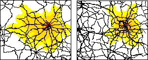


 More on this topic
Futher Information:  Carsten Schürmann

Related documents:  Project abstract - Railway and road isochrones for Berlin and Hannover


Other projects in this field of competence:

Development of a system of indicators for monitoring the development of Sorbian/Wendish culture and language and their valorisation in Brandenburg (2022 - 2023)
Atlas of Industrialisation in the New Federal States (2nd edition) (2020 - 2021)
Development indicator system for "good life" for the Lusatia (2020)
INTERCONNECT Planning Tools for Public Transport (2019 - 2020)
Concept for a German-Danish spatial monitoring system (2017)
TeMoRi - Territorial Monitoring update and Regional Potential Index for the Baltic Sea Region (2016)
eMISK II - Improvements to Beatona portal (2015)
POIs for the Greater Bremen Region (2015)
Value-added in renewable energy sector (2014 - 2015)
ESPON UpTeMo (2014)
Serengeti Nationalpark (2014)
ESPON Matrices (2014)
Purchasing Power Analysis for a Shopping Centre Location in the City of Duisburg, Northrhine-Westfalia (2013)
Service Area Analysis for City Location in Langenfeld, Northrhine-Westfalia (2013)
SWOT Analysis of the South Baltic Cooperation Programme 2014-2020 (2013 - 2014)
Rail speeds: Update of Datasets for DG Regio (2013)
HTTransPlan - Impact Assessment of Railway Tunnel between Helsinki and Tallinn (2012 - 2013)
Atlas of Industrialisation in the New German Länder (2012 - 2013)
Accessibility Potential of German Regions (2012)
Cost matrices 1970-2010 for Europe (2012 - 2013)
SUTMP Windhoek (2012 - 2013)
Service area analaysis for the City of Münster (Northrhine-Westfalia) (2012)
ESPON BSR TeMo - Territorial Monitoring for the Baltic Sea Region (2012 - 2014)
Service area analaysis for shopping centre in Düren (Northrhine-Westfalia) (2011)
GeoCensus Kuwait (2011 - 2013)
LogMos II (2011 - 2014)
ITS Deployment Plan & HTMS Riyadh (2010 - 2011)
Speeds on railway sections according to actual timetablees (2010 - 2011)
Assessment of Central Places in Bavaria (2010)
Study on Mountain Areas in Southern Norway (2010)
ESPON INTERCO - Indicators of territorial cohesion (2010 - 2012)
ESPON TRACC: Transport Accessibility at Regional/Local Scale and Patterns in Europe (2010 - 2012)
Regional Challenges in the Perspective of 2020 (2010 - 2011)
Environmental Monitoring Information System Kuwait (eMISK) (2009 - 2012)
Status Report on the Establishment of the National Environmental Information Network Kuwait (NEIN) (2009)
TRACECA IDEA (2009 - 2012)
Western NIS (2009 - 2010)
AccBavaria (2008 - 2009)
Accessibility of Zillertal (2008)
East West Window Maps (2008)
Analysis of Nordic Labour Market Areas (2007)
Central Baltic Sea Region Maps (2007)
Regional Disparities and Cohesion (2007)
RePUS (2007)
ESPON Accessibility (2006 - 2007)
ESPON 4.1.3 (2006)
Volkswagen AutoMuseum: Isochrones Maps for the Cities of Wolfsburg and Leipzig (2006 - 2007)
Accessibility Analysis of the Baltic Sea Region (2006)
FUNDING Infrastructure: Guidelines for Europe (2005 - 2007)
TRACECA: Transport Corridor Europe Caucasus Asia (2005 - 2006)
INTERREG III B (BSR) South Baltic Arc: Geodata Baltic Sea Region (2005)
Northern Peripheral, Sparsely Populated regions in the European Union (2005)
SETI (2005 - 2006)
AlpenCors (2004 - 2005)
FOPS 73.319: Regional Impacts of Transport Infrastructures (2004 - 2006)
Interaction data and regional data (2003)
RRG GIS Database (2003)
VietTrain: Toolbox for Railway Planning and Railway Management in Vietnam (2003 - 2004)
ESPON 1.1.1: The Role, Specific Situation and Potentials of Urban Areas as Nodes in a Polycentric Development (2002 - 2004)
ESPON 2.1.1: Territorial Impacts of EU Transport and TEN Policies (2002 - 2004)
Mountain Study - Analysis of mountain areas in Europe (2002 - 2004)
Via Egnatia: Motorway Case Study in Northern Greece (2002)
IASON: Spatial Impacts of European Transport Policies (2001 - 2004)
ILUMASS: Land Use and Transport (2001 - 2004)
National Atlas Germany (2000 - 2004)
Peripherality (2000)
Supply Quality of the Retail Sector – A Modelling Approach (1999 - 2000)
Ufo Working Group: The New Main Railway Station of the City of Dortmund (1999)
Interfaces between GIS, Transport Models and other Simulation Models (1997 - 2004)
Quality of Life in European Regions (1996 - 2003)
Trans-European Transport Networks (1996 - 2004)

  © RRG, 2003-2023  ·  TOP