Home   |   Contact   |   Links   |   Imprint   |   Privacy   
[Deutsche Version]  
News
Competences
Projects
All projects
Publications
About us
TCP International

Projects

TRACECA: Transport Corridor Europe Caucasus Asia (2005 - 2006)


Client:  Permanent Secretariat of the IGC TRACECA (Baku)
Partner:  Dornier Consulting (Friedrichshafen)


The TRACECA Programme was launched in 1993 to implement a programme of European Union (EU) funded technical assistance (TA) to develop a transport corridor on a west - east axis from Europe, across the Black Sea, through the Caucasus and the Caspian Sea to Central Asia, retaining the following objectives:

  • To support the political and economic independence of the republics by enhancing their capacity to access European and World markets through alternative transport routes

  • To encourage further regional co-operation among the partner states

  • To increasingly use TRACECA as a catalyst to attract the support of International Financial Institutions (IFIs) and private investors

  • To link the TRACECA route with the Trans - European Networks (TENs)


  • The TRACECA programme is financed by the European Commission, Directorate General External Relations, Europe and the Newly Independant States, Common Foreign and Security Policy, External Service Transcaucasis and Central Asia.

    To date, the TRACECA space covers the countries of Armenia, Azerbaijan, Bulgaria, Georgia, Kazakhstan, Kyrgyzstan, Moldova, Romania, Tajikistan, Turkey, Ukraine, Uzbekistan, plus recently Iran, Turkmenistan and Afghanistan (TRACECA Member States).

    The Permanent Secretariat of the IGC TRACECA commissioned RRG for the revision of the existing transport database, as well as for preparatory works for the introduction of a GIS. The overall objective of this activity was to develop a concept for the re-structuring of the present TRACECA database in order to satisfy two main criteria: (I) to pave the way for the introduction of a GI-system, and (II) to take into account the needs for future data collection from the TRACECA member states.

    The overall project was subdivided into the following tasks:
    1. Development of a new database schema for the conversion of the existing non-spatial database into a GIS-format

    2. Conversion of the existing data into a format suitable for GI-systems

    3. Proposals for the selection of an appropriate GI-system

    4. Definition of steps necessary for the introduction of the GIS


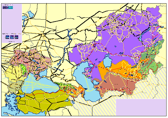
      • The TRACECA database comprises the main transport arteries of the TRACECA Member States, regional boundaries, cities and point locations as well as socio-demographic and socio-economic base data.


     More on this topic
    Futher Information:  Contact persons for this project is Carsten Schürmann. Secretary General at the IGC TRACECA is Mrs. Lyudmila Trenkova.

    Links on the web:  TRACECA webpage


    Other projects in this field of competence:

    Development of a system of indicators for monitoring the development of Sorbian/Wendish culture and language and their valorisation in Brandenburg (2022 - 2023)
    Atlas of Industrialisation in the New Federal States (2nd edition) (2020 - 2021)
    Development indicator system for "good life" for the Lusatia (2020)
    INTERCONNECT Planning Tools for Public Transport (2019 - 2020)
    Concept for a German-Danish spatial monitoring system (2017)
    TeMoRi - Territorial Monitoring update and Regional Potential Index for the Baltic Sea Region (2016)
    eMISK II - Improvements to Beatona portal (2015)
    POIs for the Greater Bremen Region (2015)
    Value-added in renewable energy sector (2014 - 2015)
    ESPON UpTeMo (2014)
    Serengeti Nationalpark (2014)
    ESPON Matrices (2014)
    Purchasing Power Analysis for a Shopping Centre Location in the City of Duisburg, Northrhine-Westfalia (2013)
    Service Area Analysis for City Location in Langenfeld, Northrhine-Westfalia (2013)
    SWOT Analysis of the South Baltic Cooperation Programme 2014-2020 (2013 - 2014)
    Rail speeds: Update of Datasets for DG Regio (2013)
    HTTransPlan - Impact Assessment of Railway Tunnel between Helsinki and Tallinn (2012 - 2013)
    Atlas of Industrialisation in the New German Länder (2012 - 2013)
    Accessibility Potential of German Regions (2012)
    Cost matrices 1970-2010 for Europe (2012 - 2013)
    SUTMP Windhoek (2012 - 2013)
    Service area analaysis for the City of Münster (Northrhine-Westfalia) (2012)
    ESPON BSR TeMo - Territorial Monitoring for the Baltic Sea Region (2012 - 2014)
    Service area analaysis for shopping centre in Düren (Northrhine-Westfalia) (2011)
    GeoCensus Kuwait (2011 - 2013)
    LogMos II (2011 - 2014)
    ITS Deployment Plan & HTMS Riyadh (2010 - 2011)
    Speeds on railway sections according to actual timetablees (2010 - 2011)
    Assessment of Central Places in Bavaria (2010)
    Study on Mountain Areas in Southern Norway (2010)
    ESPON INTERCO - Indicators of territorial cohesion (2010 - 2012)
    ESPON TRACC: Transport Accessibility at Regional/Local Scale and Patterns in Europe (2010 - 2012)
    Regional Challenges in the Perspective of 2020 (2010 - 2011)
    Environmental Monitoring Information System Kuwait (eMISK) (2009 - 2012)
    Status Report on the Establishment of the National Environmental Information Network Kuwait (NEIN) (2009)
    TRACECA IDEA (2009 - 2012)
    Western NIS (2009 - 2010)
    AccBavaria (2008 - 2009)
    Accessibility of Zillertal (2008)
    East West Window Maps (2008)
    Analysis of Nordic Labour Market Areas (2007)
    Central Baltic Sea Region Maps (2007)
    Regional Disparities and Cohesion (2007)
    RePUS (2007)
    ESPON Accessibility (2006 - 2007)
    ESPON 4.1.3 (2006)
    Volkswagen AutoMuseum: Isochrones Maps for the Cities of Wolfsburg and Leipzig (2006 - 2007)
    Accessibility Analysis of the Baltic Sea Region (2006)
    FUNDING Infrastructure: Guidelines for Europe (2005 - 2007)
    INTERREG III B (BSR) South Baltic Arc: Geodata Baltic Sea Region (2005)
    Northern Peripheral, Sparsely Populated regions in the European Union (2005)
    SETI (2005 - 2006)
    AlpenCors (2004 - 2005)
    FOPS 73.319: Regional Impacts of Transport Infrastructures (2004 - 2006)
    Interaction data and regional data (2003)
    RRG GIS Database (2003)
    VietTrain: Toolbox for Railway Planning and Railway Management in Vietnam (2003 - 2004)
    ESPON 1.1.1: The Role, Specific Situation and Potentials of Urban Areas as Nodes in a Polycentric Development (2002 - 2004)
    ESPON 2.1.1: Territorial Impacts of EU Transport and TEN Policies (2002 - 2004)
    Mountain Study - Analysis of mountain areas in Europe (2002 - 2004)
    Via Egnatia: Motorway Case Study in Northern Greece (2002)
    IASON: Spatial Impacts of European Transport Policies (2001 - 2004)
    ILUMASS: Land Use and Transport (2001 - 2004)
    National Atlas Germany (2000 - 2004)
    Peripherality (2000)
    Railway and road isochrones for Berlin and Hannover (1999 - 2000)
    Supply Quality of the Retail Sector – A Modelling Approach (1999 - 2000)
    Ufo Working Group: The New Main Railway Station of the City of Dortmund (1999)
    Interfaces between GIS, Transport Models and other Simulation Models (1997 - 2004)
    Quality of Life in European Regions (1996 - 2003)
    Trans-European Transport Networks (1996 - 2004)

      © RRG, 2003-2023  ·  TOP