Home   |   Contact   |   Links   |   Imprint   |   Privacy   
[Deutsche Version]  
News
Competences
Projects
All projects
Publications
About us
TCP International

Activity 1: Spatial Planning and Spatial Research - Projects

Peripherality (2000)

Towards a European Peripherality Index E.P.I.

Client:  European Commission, DG Regional policy (DG Regio) (Brussels)
Partners:  Institute for Spatial Planning at University of Dortmund (IRPUD) (Dortmund), The Scottish Agricultural College (SAC) (Edinburgh)

The purpose of this study for the General Directorate XVI Regional Policy of the European Commission was to calculate indicators of peripherality of the 'potential' type for the fifteen Member States of the European Union and the twelve candidate countries in Eastern Europe. The economic or population potential of a region is the total of destinations (firms or population) in all regions weighted by a function of distance from the origin region. The peripherality indicators calculated will be based on Level 3 of the Nomenclature of Territorial Units for Statistics (NUTS) of the Statistical Office of the European Union and equivalent geographical units as for the candidate countries and aggregated to NUTS levels 2, 1 and 0 as weighted average of the corresponding NUTS-3 regions. Distance measures used are average road travel times of passengers and goods taking account of road types, speed limits for cars and lorries, congestion in urban regions and of delays due to mountainous areas, national borders and maximum driving hours of lorry drivers. Selected results have been incorporated in the Second Cohension Report of the European Commission. The final report of the study can be downloaded from Inforegio homepage of the European Commission as well. The calculated indicators are part of the overall RRG GIS Database, section interaction data and regional data, and can be ordered upon request.
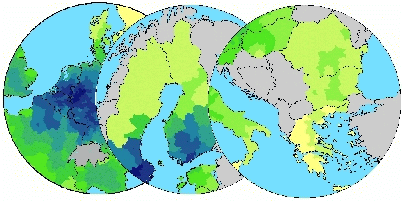


 More on this topic
Futher Information:  Carsten Schürmann or Ahmed Talaat (IRPUD).

Related documents:  Project abstract - Peripherality

Links on the web:  Inforegio Homepage


Other projects in this field of competence:

Development of a system of indicators for monitoring the development of Sorbian/Wendish culture and language and their valorisation in Brandenburg (2022 - 2023)
Atlas of Industrialisation in the New Federal States (2nd edition) (2020 - 2021)
Development indicator system for "good life" for the Lusatia (2020)
TeMoRi - Territorial Monitoring update and Regional Potential Index for the Baltic Sea Region (2016)
Value-added in renewable energy sector (2014 - 2015)
Serengeti Nationalpark (2014)
ESPON Matrices (2014)
SWOT Analysis of the South Baltic Cooperation Programme 2014-2020 (2013 - 2014)
HTTransPlan - Impact Assessment of Railway Tunnel between Helsinki and Tallinn (2012 - 2013)
Atlas of Industrialisation in the New German Länder (2012 - 2013)
SUTMP Windhoek (2012 - 2013)
Service area analaysis for the City of Münster (Northrhine-Westfalia) (2012)
ESPON BSR TeMo - Territorial Monitoring for the Baltic Sea Region (2012 - 2014)
Service area analaysis for shopping centre in Düren (Northrhine-Westfalia) (2011)
LogMos II (2011 - 2014)
Assessment of Central Places in Bavaria (2010)
Study on Mountain Areas in Southern Norway (2010)
ESPON INTERCO - Indicators of territorial cohesion (2010 - 2012)
ESPON TRACC: Transport Accessibility at Regional/Local Scale and Patterns in Europe (2010 - 2012)
Regional Challenges in the Perspective of 2020 (2010 - 2011)
Status Report on the Establishment of the National Environmental Information Network Kuwait (NEIN) (2009)
TRACECA IDEA (2009 - 2012)
Western NIS (2009 - 2010)
AccBavaria (2008 - 2009)
Analysis of Nordic Labour Market Areas (2007)
Regional Disparities and Cohesion (2007)
RePUS (2007)
ESPON Accessibility (2006 - 2007)
ESPON 4.1.3 (2006)
Accessibility Analysis of the Baltic Sea Region (2006)
FUNDING Infrastructure: Guidelines for Europe (2005 - 2007)
Northern Peripheral, Sparsely Populated regions in the European Union (2005)
SETI (2005 - 2006)
AlpenCors (2004 - 2005)
FOPS 73.319: Regional Impacts of Transport Infrastructures (2004 - 2006)
ESPON 1.1.1: The Role, Specific Situation and Potentials of Urban Areas as Nodes in a Polycentric Development (2002 - 2004)
ESPON 2.1.1: Territorial Impacts of EU Transport and TEN Policies (2002 - 2004)
Mountain Study - Analysis of mountain areas in Europe (2002 - 2004)
Via Egnatia: Motorway Case Study in Northern Greece (2002)
IASON: Spatial Impacts of European Transport Policies (2001 - 2004)
ILUMASS: Land Use and Transport (2001 - 2004)
Supply Quality of the Retail Sector – A Modelling Approach (1999 - 2000)
Ufo Working Group: The New Main Railway Station of the City of Dortmund (1999)
Quality of Life in European Regions (1996 - 2003)

  © RRG, 2003-2023  ·  TOP