VietTrain: Toolbox for Railway Planning and Railway Management in Vietnam (2003 - 2004) |
|
|
|
As the Vietnamese Railway Company is currently undergoing a process of privatisation and as Vietnam as a country is currently undergoing a transition phase from socialism to a more market-oriented society, this project aims at developing computer-based tools for railway planning and railway management in Vietnam. These tools should assist and facilitate railway planning processes of new railway lines and new train stations, as well as facilitate the management of existing lines and stations. As a common principle all tools rely on the same overall GIS database of Vietnam railways. The development of the database is also part of this project. Moreover, as Vietnam is still a rather poor country with limited management capacities, it is essential for the acceptance of the tools that their application is rather simple and effective. Thus, concern is given not to implement latest state-of-the-art software tools but easy-to-understand and easy-to-apply but yet powerful and effective tools, that can be implemented with limited budgets and limited human resources by a railway company that currently experiences a rapid transition phase.
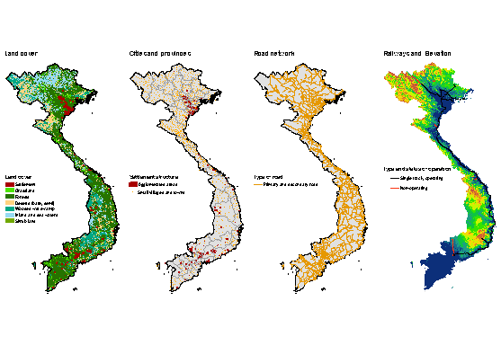
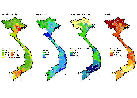
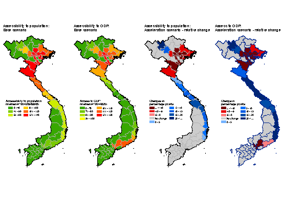
The following maps provide overviews on the socio-economic situation in Vietnam at a glance.
1. Land cover, cities and provinces, and infrastructure
- Land cover (left)
- Cities and provinces (middle-left)
- Road network (middle-right)
- Rail network and relief (right)
2. Socio-economic situation
- Population density (left)
- Employment (middle-left)
- Gross-domestic product (GDP) (middle-right)
- Poverty (right)
3. Accessibility
- Accessibility to population, base scenario (left)
- Accessibility to GDP, base scenario (middle-left)
- Accessibility to population, relative change (middle-right)
- Accessibility to GDP, relative change (right)
|
|
|


