 |
 |
|
|
|
Projects
Railway and road isochrones for Berlin and Hannover (1999 - 2000) |
|
|
|
Methodological Aspects
Carsten Schürmann
People usually judge transportation network quality under the aspect of travel times. How long does it take to travel from City A to City B or how many cities are accessible in a given time period? Therefore the transport planning projects focus on travel time savings by improving pan-European transportation networks to stimulate and strengthen regional economies. The projects are characterised by upgrading existing or constructing new road or rail links. Moreover, these policies do not only aim at strengthening of regional competitiveness but also at reducing spatial disparities in improving accessibility of peripheral regions to the core by new transportation links (cohesional objectives). On the European level these objectives are laid down in the Trans European Transportation Networks Outline Plans (European Communities 1996); in Germany they are laid down on the federal level in the so-called 'Bundesverkehrswegeplan' (Bundesminister für Verkehr, 1992), most recently specified in the 'Verkehrsprojekte Deutsche Einheit' (German Unification Transportation Projects)
In cartographic illustrations, travel times are usually represented by so- called isochrone maps. Besides this there are other techniques such as 'time space maps' (Spiekermann and Wegener, 1993, 1994) or 'accessibility surfaces' (Schürmann, Spiekermann, Wegener 1997). Travel time savings or travel time differences between two or more modes are then applied by comparing two isochrone maps for different years in time or different modes. These isochrones enclose the area that can be reached from a given origin within a certain time.
On the basis of digital trans-European road and rail transportation networks IRPUD developed 30, 60, 90 and 120 minutes travel time isochrone maps from Berlin for passenger rail and road transport. Rail travel times are taken from the German railway company time-table (Deutsche Bahn 1998), whereas road travel times are based on a Shell route finder (Shell 1997). The disaggregated calculation of the isochrones for both the rail and road networks is fully implemented within the geographical information system ARC/INFO. In the GIS the travel times are available as 'routes' within the road and rail layers (see Figure 1).
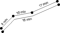
Figure 1. Travel time information as routes in the digital database.
In a first step the ARC/INFO command ROUTEARC is applied which transfers the routes into arcs. The calculation of travel times between the centre of Berlin and every network node is in the following done by running the NODEDISTANCE command. The result of this command are the fastest network travel times for every node from the centre of Berlin, provided that they are enclosed by the specified isochrone. The time difference between the calculated travel time (e.g. 25 minutes) and the isochrone considered (e.g. 30 minutes) must then be transferred into spatial units to define the node hinterland (station resp. network access commuter- belt) which is still covered by the isochrone considered. In this approach, the remaining time (for example 5 minutes) is transferred to the hinterland with an assumed average access speed of 30 km/h. This leads to an node catchment area with a radius of 2.5 km which is also enclosed by the 30 minutes isochrone. These hinterland access areas are calculated within ARC/INFO applying the BUFFER command. Figure 2 illustrates the rail travel time isochrones for the Berlin agglomeration area:
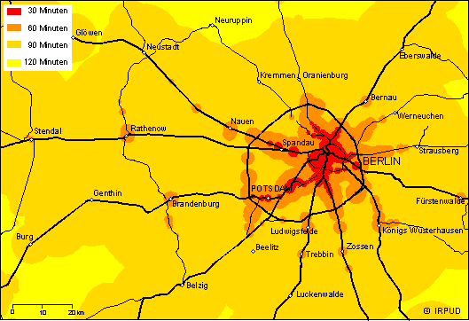
Figure 2. Rail travel time from Berlin (suburban).
Within 30 minutes most of the core area of Berlin can be reached. Also some remote districts of Berlin such as Berlin-Wannsee or Berlin-Spandau are reachable. Compared with this the 60 minutes isochrone encloses almost the entire city of Berlin plus some important railway stations in the hinterland such as Potsdam, Königs Wusterhausen as well as some more distant cities such as Brandenburg or Rathenow. The figure displays some kind of 'fingers' along regional railway routes, which reach far into the hinterland. Generating the 60 minutes road isochrone for the road network in the same manner, from implementation perspectives it is important, that this isochrone encloses no connected area but results in some kind of 'offshore islands'. For the rail network these islands are plausible, because they represent the only rail access points, namely the stations. For the road network these islands are not plausible in that respect, with the exception of motorways, that in principle there is network access at every point on the street.
Conceptually this means, that the nodes within the road network must be densified, because the NODEDISTANCE command mentioned above operates for nodes only. This densification needs to be applied for every category of roads except for motorways, because every motorway exists is still represented by a node. From the GIS user's point of view this means that the digital road network is divided into a 'motorway' coverage and a 'other roads' coverage. The number of nodes in the latter coverage is then increased by applying the DENSIFYARC command. Afterwards both coverages are merged together again (APPEND) and the travel time calculation is run. Figure 3 shows then the results for all the four isochrones for the road network:
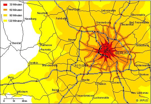
Figure 3. Road travel times for Berlin (suburban).
As expected, the 60 minutes isochrone still comprises the suburban area of Berlin with some exceptions in the North – Oranienburg – and East), but covers now a contiguous area. The 90 minutes isochrone encloses amoeba- like the entire city of Berlin as well as some neighbouring cities: Neuruppin in the north-west, Eberswalde in the north-east, Lübbenau in the south-east and Brandenburg in the south-west. The 120 minutes isochrone reaches finger-like along the motorways much wider into the hinterland.
Figure 4 illustrates all the four isochrones for the rail network in comparison.
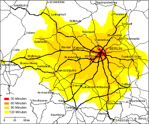
Figure 4: Rail travel times from Berlin (long-distance).
Because of fast intercity and ICE lines the 120 minutes isochrone encloses Hannover in the west, Dresden in the south, Schwerin in the north and some areas in Poland in the east. Even the 90 minutes isochrone covers the entire Bundesland Brandenburg with the cities of Wolfsburg, Magdeburg, Salzwedel and Elsterwerda in addition. These cities are stations of fast interregional, intercity or ICE railway links, which also grant accessibility of these hinterland regions to Berlin.
Comparing the results of the road and rail networks, the common sense of faster road connections is disproved. The number of cities reachable within a certain time is much lower going by car than by train because of congestion, speed limits and long delay times at traffic lights within the road network. So all four rail isochrones cover a much greater area each than the road isochrones.
This application shows that by using GIS isochrone maps can be generated with greater detail and accuracy ('offshore islands' in the rail isochrones, 'finger-like' structures in the road isochrones) than manually approaches do. This leads to a more realistic view of the world.
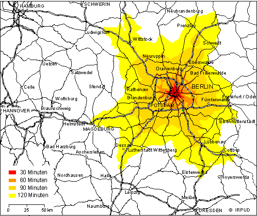
Figure 5. Road travel times for Berlin (long-distance).
Using this methodology, rail and road isochrones have also been calculated for Hannover as contributions to the Nationalatlas Bundesrepublik Deutschland, Band Verkehr und Kommunikation. In general, using the RRG GIS Datenbasis each specific point of interest can be used as the origin for constructing isochrones. In the framework of ESPON Project 1.1.1. this method had been applied to delimitate so-called Functional Urban Areas for 1,595 cities in Europe. In the project VietTrain this method will be integrated as important tool for analysing the quality of the existing railway network and for assessing planned railway sections.
References
Bundesministerium für Verkehr (1992): Bundesverkehrswegeplan 1992. Decision of the Government of the Federal Republic of Germany from 15th July 1992: Bonn.
Deutsche Bahn AG (1998): Kursbuch 1998/99.
European Communities (1996): 'Decision No. 1692/96/EC of the European Parliament and of the Council of 23 July 1996 on Community guidelines for the development of the trans-European transport network'. Official Journal of the European Communities 39, L 228, 9 September 1996, 1-104.
Schürmann, C., Spiekermann, K., Wegener, M. (1997): Accessibility Indicators. SASI Deliverable D5. Berichte aus dem Institut für Raumplanung 39. Dortmund: Institut für Raumplanung.
Shell AG (1997/98): Der große Shell Atlas 97/98. Deutschland/Europa. Mit elektronischem Routenplaner Deutschland. Mairs Geographischer Verlag: Ostfildern. 1997/98
Spiekermann, K., Wegener, M. (1993): Zeitkarten für die Raumplanung. Informationen zur Raumentwicklung 7. 1993, 459-487.
Spiekerman, K., Wegener, M. (1994): The Shrinking Continent. New Time Space Maps of Europe. Environment and Planning B: Planning and Design 21, 653-673.
|
|
|
|
|
|


