 |
 |
|
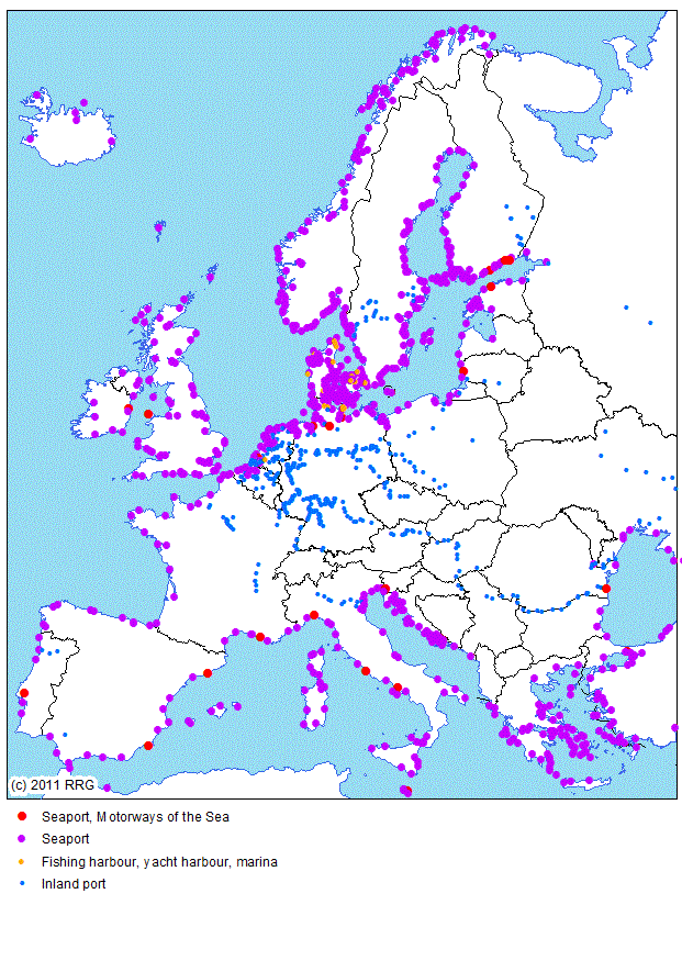
RRG GIS DatabaseTransport networks - Inland ports and seaportsGeneral information This layer is a layer derived from the overall waterway network, representing inland ports and seaports as points in space. The RRG European waterway network contains some 432 inland and 379 sea ports. A full list of all inland ports and seaports available in the dataset can be found here. As a basic principle, nodes representing inland ports or seaports in the overall waterway network layer are represented here as point features, and vice versa. It is ensured that information provided in both datasets is compatible to each other. The name of the layer containing the inland ports and seaports is PORTS and comprises a point feature class only. Its main characteristics are: Layer name: PORTS Feature classes: Points No of point features: 811 User attributes associated with the points: 8
Detailed description of the point attribute table The user defined fields of the PORTS layer are as follows:
NODEID is a unique identifier for each inland and seaport. The first three digits indicate the number of the region in which the node is located. The number givenhere is equal to the number given in NODEID1 of the NAT of the WATERWAY layer, thus this attribute can be used to link the PORTS layer to the overall waterway layer WATERWAYS, and vice versa. COUNTRY indicates the ISO code of the country in which the node is located. REGION is a four-character acronym of the name of the region. The main city (not necessarily the greatest city) of each region is the centroid of the region. For each region the nodes are counted from 0001. LABEL gives general information on all ports. PORTNUMBER represents a unique port identifier in integer format. In addition to NODEID, this attribute can be used to link for further information and data to (sea)ports, or to link the overall waterway layer WATERWAYS to this layer, and vice versa. CATEGORY and TENCAT give information on those inland and sea ports included in the "Trans European Transport Network Outline Plan, Section Waterways" based on the Joint Decision of the European Parliament and of the Council published in the Official Journal of the European Communities (L228, 9 September 1996) or are part of the TINA network (TINA Secretariat, 1999; 2002). CATEGORY distinguishes between TEN ports (located in the old EU member states) and TINA ports (located in the candidate countries) and those ports added to the strategic modelling network. TENCAT can be used to differentiate between sea and inland ports, and those ports with or without facilities for combined transport.
RRG GIS Database contents:General informationTransport networks Available transport datasets Geography Interaction data and regional data |
|||||||||||||||||||||||||||||||||||||||||||||||||||||||||||||||||||||||||
|
|||||||||||||||||||||||||||||||||||||||||||||||||||||||||||||||||||||||||

