|
|
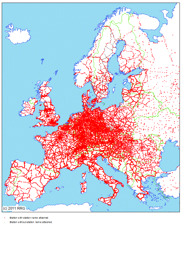
RRG GIS DatabaseTransport networks - Railway stations in EuropeGeneral information This layer is a layer derived from the overall railway network, representing railway stations as points in space. The RRG European rail network contains all passenger train stations which are under operation today, plus planned (future) ones (as far as information are available) and many of those that are currently closed or abandoned. In addition, the rail network layer also includes many freight and cargo stations (such as road-rail transshipment points, ports, major industry terminals, container transshipment facilities), as well as train depots and marshalling yards. For many agglomerations tram and subway stations are coded in the database as well. Several attributes allow to differentiate the stations by station type and by special characteristics, as explained further below. Altogether, there are currently approx. 65,000 railway, tram or subway stations coded in the layer. As a basic principle, nodes representing stations of the overall railway network layer are represented here as point features, and vice versa. It is ensured that information provided in both datasets is compatible to each other. The name of the layer containing the trans-European railway stations is RAILSTAT and comprises a point feature class. Its main characteristics are: Layer name: RAILSTAT Feature class: Points No of point features: 64,964 User attributes associated with the points: 18
Detailed description of the point attribute table The PAT of the RAILSTAT coverage contains the following user-defined attributes:
NODETYPE and NODEGROUP indicate the type of the node in the network. Centroids, border nodes, rail ferry ports, rail junctions and branchings, as well as railway, tram and subway stations and tunnel and bridge portals are differentiated. Rail nodes (NODETYPE=2) are used at locations where the characteristics of the railway tracks change (e.g. where a one track line is changing to a dual track line). NODETYPE can also be used to establish a hierarchy of railway stations: main stations (NODETYPE=5), regional train stations (NODETYPE=9), secondary passenger train stops (NODETYPE=10), freight terminals (NODETYPE=6), ferry seaports (NODETYPE=3) and stations out of operation (NODETYPE=11). However, NODETYPE reflects only the main character of a node. A node identified as railway station (NODETYPE=5) may, at the same time, also represent a rapid urban train or IC station. Therefore, the attributes ECESTAT, ICESTAT and REGSTAT provide further information on the character of a station: ECESTAT identifies stations for long distance (cross-border) trains (i.e. intercity trains, Eurocity trains), whereas ICESTAT identifies high-speed train stations, and lastly REGSTAT identifies stations with rapid regional trains. At any station, at the same time rapid regional trains, long distance (international) trains and high-speed trains may stop. NODEGROUP provides a more aggregated differentiation of the nodes, while distinguishing only between centroids, border nodes, rail nodes, stations and station entrances. By using NODEGROUP a general selection of all stations is much more convenient. Sometimes major stations may have different station entrances at either side of the railway line. The station entrances are modelled explicitly (NODEGROUP=4); they are linked to the station node by so-called �pathways� (see description of rail links feature class). Similarly, if a major station also comprise tram or subway station, the tram or subway station is linked to the train station via these pathways. By that, pathways help to model connecting times between trains, tramways and subways properly. OPERATION indicates the operation status of a station, whether the station is under operation, is being planned (or constructed), is closed or is expected to be reactivated. PNR provides a unique station node point number (in integer format), while PLATFORMS indicates the number of gates. NODEID1 is a unique identifier for each node in the network. The first three digits indicate the number of the region in which the node is located. COUNTRY1 indicates the ISO code of the country in which the node is located. REGION1 is a four-character acronym of the name of the region. The main city (not necessarily the greatest city) of each region is the centroid of the region. For each region the nodes are counted from 0000, with 0000 indicating the centroid. A full list of the region centroids can be found here in tabular format. Column 3 of this table illustrates the region name, whereas the last column indicates the name of the centroid. The 1995 NUTS 2 region code is also provided (corresponding to the REGION1 attribute) there. Furthermore, column 2 of this table also illustrates the unique region number, which corresponds to the region-ID in the NODEID1 attribute. CONTINENT indicates the name of the continent on which the rail node is located. Border nodes are nodes at national borders. At each border crossing there is a border node. Border nodes have two node numbers, country codes and region codes indicating that they belong to two different, neighouring countries. Thus, border nodes do have entries in the attributes NODEID2, COUNTRY2 and REGION2, providing the same information for the neighbouring country. In contrast, regular rail nodes have no entries in NODEID2, COUNTRY2 and REGION2. LABEL gives general information about the name/designation of a node. The label may represent the name of a station, may represent the name of a ferry port, a border crossing or the name of a region centroid. Sometimes also the name of important tunnel portals or bridges are provided. If a node represents a station, LABEL gives the name of the station. If a node represents a border node, LABEL shows a BORDER string, followed by the names of the two respective countries. If the node represents a region Centroid (NODETYPE=0) than LABEL will be constituted by the name of the centroid followed by the capital letter C (=CENTROID). For example, the Berlin centroid will be indicated like Berlin C. Sometimes, a station has different station names. In such cases the attribute NAMES_ALIAS provides such alternative node labels. For railways, the actual TEN-T programme distinguishes between passenger and freight lines, and moreover between core and comprehensive networks, resulting in different TEN-T networks such as - core passenger network (field COREPASS) - comprehensive passenger network (field COMPPASS) - core freight network (field COREFREIGHT) - comprehensive freight network (field COMPFREIGHT) The fields COREPASS, COREFREIGHT, COMPPASS and COMPFREIGHT thus indicate whether or not a rail node is located along any of these networks. Other subsets of the overall TEN-T network constitute nine different corridors, whose further development is of prime interest for the European Union. Any rail link might belong to none, to just one or to two or more of these corridors. The attribute CORRIDORS thus indicates along which corridor a rail node is located. By using these columns, one can for example query which stations belongs to which subset of the TEN-T network. Eventually, the column TEN aggregates such information allowing to identify those nodes located along any TEN-T axis from those located aside any TEN-T axis. NETTYPE indicates the type of link (network) a rail node is located along. A node may be located along a link purely used for passenger (NETTYPE=�PASS�) or for freight (NET-TYPE=�FREIGHT�) services, or both (NETTYPE=�PASS, FREIGHT�), or may be located along a closed link (NETTYPE=�CLOSED�) or access link (NETTYPE=�ACCESS�). This field looks only at the link designation, while it does not indicate the actual node type (as the field NODETYPE does). So, NETTYPE=�PASS� for instance does not necessarily mean that the node is a passenger station, but it only says that the node is located along a link which is only operated by passenger trains. The node itself might nevertheless represent a junction, a tunnel or bridge portal. By querying NETTYPE, one can easily identify or select nodes that are located along a specific link type. Similar to the arc feature class, there is an optional attribute available in the node feature class that might be of interest for transport planning purposes. This attribute is called ELEVATION and represents the elevation above sea level at the node location. This attribute is derived by GIS techniques through an overlay of the railway network layer with a digital terrain model. here
RRG GIS Database contents:General informationTransport networks Available transport datasets Geography Interaction data and regional data Informationen zur RRG GIS Datenbasis sind nur auf Englisch verfügbar. |
||||||||||||||||||||||||||||||||||||||||||||||||||||||||||||||||||||||||||||||||||||||||||||||||||||||||||||||||||||||||||||||||||||
|
||||||||||||||||||||||||||||||||||||||||||||||||||||||||||||||||||||||||||||||||||||||||||||||||||||||||||||||||||||||||||||||||||||