Home   |   Contact   |   Links   |   Imprint   |   Privacy   
[Deutsche Version]  
News
Competences
Projects
All projects
Publications
About us
TCP International

Activity 2: GIS and GIS-Applications - Projects

Railway and road isochrones for Berlin and Hannover (1999 - 2000)


Client:  own research
Partner:  Institute for Spatial Planning at University of Dortmund (IRPUD) (Dortmund)

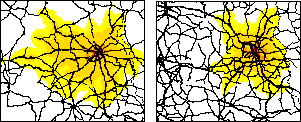
People usually judge the quality of the transportation networks under the aspect of travel times. How long does it take to travel from City A to City B or how many cities are accessible or which area is reachable in a given time period? The latter aspect is usually represented by so-called travel time isochrones. These isochrones enclose the area that can be reached from a given origin within a certain time. On this background 30, 60, 90 and 120 minutes travel time isochrone maps from Berlin and from Hannover for passenger rail and road transport were generated. The travel time isochrones are based on the RRG GIS trans-European road and rail transportation networks. The isochrones for Hannover were published in Volume 9 „Communication and Transport“ of the Nationalatlas Bundesrepublik Deutschland. Basically, any desired origin can be selected using any desired time thresold for the generation of such isochrones. The same further improved methodology was also applied in ESPON Project 1.1.1 to construct 45-minute isochrones as basis for the delimitation of so-called Functional Urban Areas. Moreover, this method will also be integrated into the toolbox for railway planning and railway maintenance currently developed in the framework of the VietTrain project. A short description of the methodology to construct isochrones can be found here.


 More on this topic
Futher Information:  Carsten Schürmann

Related documents:  Project abstract - Railway and road isochrones for Berlin and Hannover


Other projects in this field of competence:

INTERCONNECT Planning Tools for Public Transport (2019 - 2020)
Concept for a German-Danish spatial monitoring system (2017)
eMISK II - Improvements to Beatona portal (2015)
POIs for the Greater Bremen Region (2015)
ESPON UpTeMo (2014)
Purchasing Power Analysis for a Shopping Centre Location in the City of Duisburg, Northrhine-Westfalia (2013)
Service Area Analysis for City Location in Langenfeld, Northrhine-Westfalia (2013)
Accessibility Potential of German Regions (2012)
GeoCensus Kuwait (2011 - 2013)
ITS Deployment Plan & HTMS Riyadh (2010 - 2011)
Environmental Monitoring Information System Kuwait (eMISK) (2009 - 2012)
Accessibility of Zillertal (2008)
East West Window Maps (2008)
Central Baltic Sea Region Maps (2007)
Volkswagen AutoMuseum: Isochrones Maps for the Cities of Wolfsburg and Leipzig (2006 - 2007)
TRACECA: Transport Corridor Europe Caucasus Asia (2005 - 2006)
Interaction data and regional data (2003)
RRG GIS Database (2003)
VietTrain: Toolbox for Railway Planning and Railway Management in Vietnam (2003 - 2004)
National Atlas Germany (2000 - 2004)
Interfaces between GIS, Transport Models and other Simulation Models (1997 - 2004)
Trans-European Transport Networks (1996 - 2004)

  © RRG, 2003-2023  ·  TOP